- Free OGG to MP3 Converter
- Free FLV to AVI Converter
- Free WMA to MP3 Converter
- Free MP3 To Wave Converter
- Free RM to MP3 Converter
- Free Mario Game
- Free XLS Viewer
- Free WAV to MP3 Converter
- Free Aquarium Screensaver
- Free DVDFab Decrypter
- Free Mobile 3GP converter
- Free PDF to Flash Converter
- Free MP4 to AVI Converter
- Free PDF to Word Converter
- Free MP3 to WAV Converter
- Free File List
- Free FLV to MP3 Converter
- Free Wallpaper Changer
- Free DVD to MPEG Converter
- Free Doc Convertor
- Free Audio Editor
- Free Video to WMV Converter
- Free YouTube to FLV Converter
- Free MP3 Editor
- Free Video to MP3 Converter
- Free PDF Creator
- Free Sound Recorder
- Free AMR to MP3 Converter
- Free MOV to AVI Converter
- Free DivX Converter
- Free Wave To MP3 Converter
- Free Aquarium Screensaver
- Free XLS Viewer
- Free PDF to Word Converter
- DriverHub
- Your Link Here
- This site for sale
- Free HD Video Converter Factory
- WonderFox DVD Ripper Speedy 13.
- Vartika Zimbra to PST Converter
- Free Android Data Recovery 1.1.
- Aiseesoft Video to GIF Converte
- Google Selection Search 1.0
- Apeaksoft Free HEIC Converter 1
- Best PDF to Word Converter 3.5
- MSG Files Without Email Client
- DriverHub 1.1.2
- MSG Viewer Freeware 4.0
- Read PST File Opener Free Downl
- Free Download EML File Reader T
- Easy Photo Studio Free for Wind
- Easy Photo Studio Free for Mac
- PST File Reader Without Outlook
- Free YouTube to FLV Converter
- Free MP3 Editor
- Free Video to MP3 Converter
- Free PDF Creator
- Free Sound Recorder
- Free AMR to MP3 Converter
- Free MOV to AVI Converter
- Free DivX Converter
- Free Wave To MP3 Converter
- Free Aquarium Screensaver
- Free XLS Viewer
- Free PDF to Word Converter
- DriverHub
- Your Link Here
- This site for sale
Download free program OkMap 8.8.0 for free
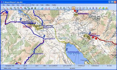
OkMap is an interactive software which allows you to work on your computer screen with digital maps that you have
OkMap is an interactive software which allows you to work on your computer screen with digital maps that you have either bought or scanned. OkMap can also import vectorial data from the most common formats and DEM data relevant to height informations.
Through these maps, OkMap lets you organize paths by creating waypoints, routes and tracks on your computer monitor, and upload this data to your GPS. To make it easier, OkMap provides you also with autorouting and geocoding functions. Data collected by your GPS can be downloaded on your computer, stored and displayed on the maps. They can also be used to create different types of statistics. By connecting a GPS to your laptop, you can plot your position on maps in real-time. If you are connected to the network you can constantly send your position to a remote computer, or receive the position of your companions on your computer and display the related tracks on maps in real time.
OkMap can also interface Google Maps and Google Earth. With Google Maps you can get portions of maps immediately available in OkMap. With Google Earth you can view your paths and your maps also in 3D.
Potential use:
- Search and rescue
- Trekking
- Off road
- Boating
- Flying
- Mountain bike
- Geocaching
- Hunting and fishing
- Finding mushrooms
- Soft air
Features
- Calibrate raster maps with different types of cartographic projections
- Create own digital maps drawing points, multipoints, polylines and polygons
- Display simultaneously raster and vectorial maps
- Import vectorial data with different types of cartographic projections
- Use raster and vectorial maps as background for navigation
- Create and manage waypoints, routes and tracks in GPX format
- Download, save and automatically georeference maps from Google Maps
- Automatic determination of road paths (autorouting)
- Determination of coordinates from street addresses (geocoding) and viceversa
- Use digital terrain models to display the elevation
- Upload and download data to and from a GPS device
- Navigate in real time with a GPS device through NMEA protocol
- Display Google Earth and Google Maps in current map location
- Exchange data with Google Earth and view your map in 3D
- Find nearby cache in geocaching.com web site
- Exchange data with gpsgate.com server
- Receive customized navigation data from remote GPS devices
- Send the current position to an OkMap remote server
- Make conversions between different types of coordinates, datums, formats, etc..
- Use a handy calculator for your calculations
- Many other things..
Supported formats:
- Images: ecw, bmp, gif, jpg, png, tif and many others
- Maps: gfw, jgw, pgw, tfw, bpw (Drg maps); ecw (Earth Resource Mapping); map (OziExplorer); gmi (GpsTuner)
- Vectorial data: shp, dbf (Esri shape file); dcw (Digital Chart of World)
- GPS data: gpx (GPS Exchange Format); kml (Keyhole Markup Language); wpt, plt, rte (OziExplorer); loc (Geocaching) and many others formats thanks to the software GpsBabel
- DEM data (digital earth model): hgt (SRTM-1 e SRTM-3)
Supported Gps devices:
- Upload/download: all GPS devices supported by GpsBabel
- NMEA navigation: all GPS devices that support Nmea 0183 protocol
- Require .Net Framework 2.0